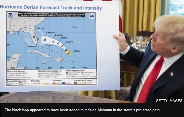
When President Donald Trump updated the US public on Wednesday about Hurricane Dorian, he used a map that at a glance looked identical to one released by forecasters last week.
But observers spotted a difference.
A "cone" showing the storm's probable path appeared to have been extended with a felt-tip pen to include part of the state of Alabama, analysts said.
The president has insisted in recent days Alabama was at risk, though forecasters said that was not correct.
What did President Trump say on Wednesday?
In an Oval Office briefing, Mr Trump pointed to a National Oceanic and Atmospheric Administration's (NOAA) forecast map from 29 August.
The chart had a black loop marked around Alabama that was not on the original version from last week.
Mr Trump told reporters that Dorian "would have affected a lot of other states".
Later on Wednesday at a White House event, when asked about the map discrepancy, Mr Trump offered no explanation. "I don't know," he said.
"I know Alabama was in the original forecast, they thought it would get a piece of it," Mr Trump said.
NOAA directed queries to the White House press office, which did not immediately respond.

In its latest Dorian advisory on Wednesday, the National Hurricane Center (NHC) issued a storm surge warning covering the coasts of Georgia, South Carolina and North Carolina.
The hurricane hit the Bahamas with winds equalling the highest-ever recorded at landfall, before moving north late on Tuesday. At least 20 people were killed on the archipelago.

